


Voting District 0047, Smith County, Texas
About
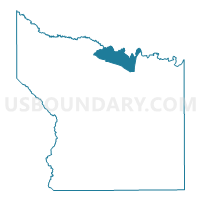
Outline

Summary
| Unique Area Identifier | 676797 |
| Name | Voting District 0047 |
| County | Smith County |
| State | Texas |
| Area (square miles) | 24.08 |
| Land Area (square miles) | 23.48 |
| Water Area (square miles) | 0.60 |
| % of Land Area | 97.52 |
| % of Water Area | 2.48 |
| Latitude of the Internal Point | 32.53357730 |
| Longtitude of the Internal Point | -95.22117010 |
Maps


Graphs
Select a template below for downloading or customizing gragh for Voting District 0047, Smith County, Texas


Neighbors
Neighoring Voting District (by Name) Neighboring Voting District on the Map
- Voting District 0005, Smith County, TX
- Voting District 0006, Smith County, TX
- Voting District 0007, Smith County, TX
- Voting District 0008, Smith County, TX
- Voting District 0012, Upshur County, TX
- Voting District 03-3, Wood County, TX
Top 10 Neighboring County Subdivision (by Population) Neighboring County Subdivision on the Map
- Lindale CCD, Smith County, TX (21,255)
- Hawkins CCD, Wood County, TX (8,406)
- Big Sandy CCD, Upshur County, TX (5,980)
- Winona CCD, Smith County, TX (5,646)
Top 10 Neighboring Place (by Population) Neighboring Place on the Map
Top 10 Neighboring Unified School District (by Population) Neighboring Unified School District on the Map
- Lindale Independent School District, TX (19,274)
- Winona Independent School District, TX (5,635)
- Hawkins Independent School District, TX (5,433)
- Big Sandy Independent School District, TX (4,312)
Top 10 Neighboring State Legislative District Lower Chamber (by Population) Neighboring State Legislative District Lower Chamber on the Map
Top 10 Neighboring State Legislative District Upper Chamber (by Population) Neighboring State Legislative District Upper Chamber on the Map
Top 10 Neighboring 111th Congressional District (by Population) Neighboring 111th Congressional District on the Map
Top 10 Neighboring Census Tract (by Population) Neighboring Census Tract on the Map
- Census Tract 9505, Upshur County, TX (5,980)
- Census Tract 14.04, Smith County, TX (5,724)
- Census Tract 15, Smith County, TX (5,646)
- Census Tract 9506.01, Wood County, TX (4,150)